From the two places Seattle actually sees itself, the skyline has a hole in it, right between Columbia Center and Rainier Square. The next tallest building in Seattle goes exactly there. We can show you where to stand.
A skyline is a designed object. Most cities refuse to believe this. They treat the silhouette of their downtown as the accidental sum of forty separate financing decisions, and it shows. The cities that take it seriously, Paris composing its axis, Chicago arranging its wall of towers along the lakefront the way Burnham drew it in 1909, get skylines that read as one deliberate thing from the places people actually see them.
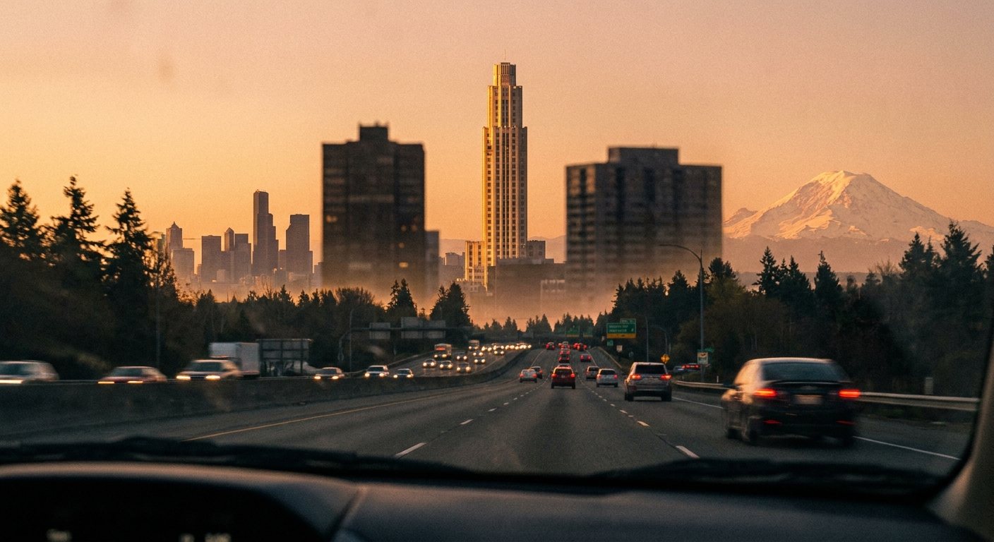
Start with a simpler question: where do people actually see Seattle's skyline? Strip out the helicopter shots and the marketing renderings, and the honest answer is a windshield on Interstate 5, hundreds of thousands of times a day. And from I-5 there are two moments, one coming up from the south and one coming down from the north, when the skyline presents itself whole.
The Two Vantage Points
South: I-5 northbound at SeaTac (47.4265 N, 122.2791 W), twelve miles out. The freeway crests and downtown rises off the horizon for the first time.
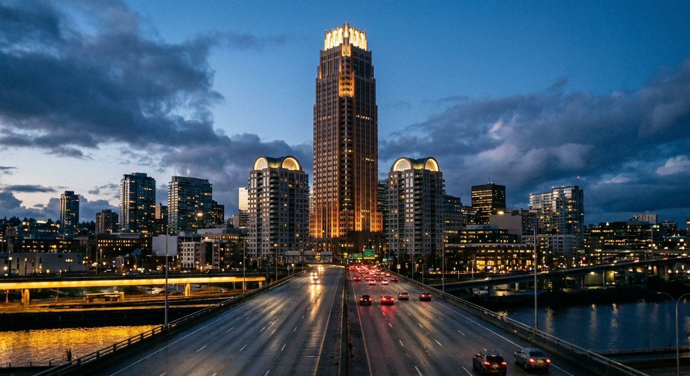
North: I-5 southbound at the crest of the Ship Canal Bridge (47.6521 N, 122.3226 W), three miles out. The deck climbs and the whole skyline opens across the water.
These are the two front doors of the city. Hundreds of thousands of people pass through them every day. Arriving from the airport, the SeaTac rise is the first time a visitor sees Seattle. Coming home from the north, the Ship Canal crest is the moment the city declares itself. No public space, no park, no viewpoint comes close to the daily audience of these two stretches of freeway.
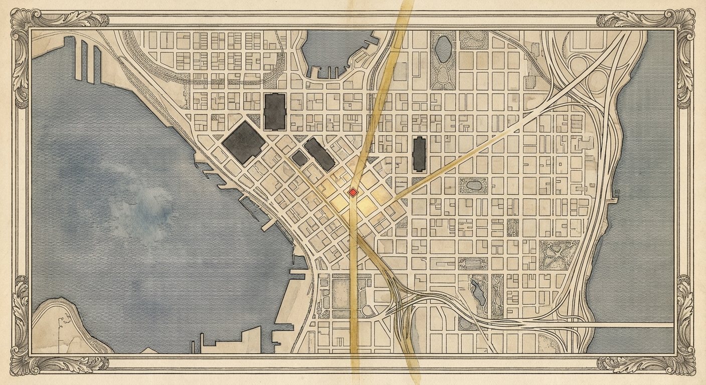
And from both of them, the skyline says the same thing. Two masts hold the composition up: Columbia Center at 933 feet, the tallest building in Seattle since 1985, and Rainier Square Tower at 850 feet, finished in 2020. They stand about half a mile apart on the downtown spine. From the SeaTac rise they sit nearly in line, a front mast and a back mast. From the Ship Canal crest they frame the center of the view.
Between them: air. A sag in the middle of the composition, visible from both front doors at once. The skyline has a gap where its summit should be.
Schematic elevation of the downtown skyline as composed from the two I-5 vantage points. The two tallest buildings frame a visible gap on the Fourth and Fifth Avenue spine.
Where the Gap Touches the Ground
Run the sightline from each vantage point through the space between the two towers and the lines land on the same ground: the Fourth and Fifth Avenue spine between Cherry Street and University Street, centered around Fourth and Madison. This is the financial district's old heart, and it is conspicuously underbuilt for the most visible ground in the city.
The city has already seen what belongs there. In 2015, Crescent Heights proposed 4/C at Fourth and Columbia, on the half block between Cherry and Columbia: 1,111 feet and 102 stories, taller than Columbia Center by 178 feet. The FAA issued a notice of presumed hazard in January 2016 over SeaTac and Boeing Field flight paths and recommended 965 feet. The design came back at 1,029 feet and 93 stories. A decade later it remains unbuilt, and the gap remains a gap.
933 ft Columbia Center, tallest in Seattle since 1985, 41 years and counting
850 ft Rainier Square Tower, 2020
1,029 ft the FAA-shaped envelope already proven out by the 4/C review
0 buildings over 933 feet built, started, or permitted
That is the whole opportunity in four lines. The zoning in the downtown office core allows the height. The FAA review already established the real ceiling, in the band just above 1,000 feet. The most visible parcels in the city sit in the exact corridor where a summit tower would complete the composition from both freeway approaches at once. Forty-one years is a long time for a city this rich to go without raising its own roofline.
So we went looking for the parcel, and we found two answers. There is a site inside the gap that is already entitled for over 1,000 feet and is on the market right now at a discount to its 2015 price. And when we ran the sightline math properly, block by block, the geometry pointed at an even better piece of ground that nobody is talking about. Both are in the member file, along with the math.
MEMBERS
The Parcel File: Where the Summit Tower Goes
The sightline math, run block by block, and the bullseye where the two lines cross
The visual-height problem: which building actually reads tallest from the north, and the number that beats it
The entitled site, its asking price, and why it is below the 2015 basis
The full target list, and the FAA picture as it stands today
Incorrect password.
MEMBERS FILE
The Bullseye
Run the centerline of the gap from each vantage point and extend the two lines until they cross. From the SeaTac rise, Columbia Center and Rainier Square sit at bearings of 348.9 and 348.6 degrees, nearly one mast behind the other, and the center of that gap runs straight up the Fourth Avenue spine. From the Ship Canal crest, the same two towers sit at 186.4 and 190.5 degrees, and the centerline of the gap leaves the bridge at 188.5. The two lines intersect at 47.6078 north, 122.3323 west.
That point is the 1100 block of Fourth Avenue, between Spring and Seneca, one block north of the Central Library. Standing on it today: hotels and a parking garage. Mid-rise hospitality, not legacy towers, which makes the bullseye one of the most acquirable pieces of ground in the band. No entitlement exists there, and at this location that is a detail, not a wall, for reasons covered below.
We pulled the county assessor's roll for the block. Four parcels, four owners, and one of them is a gift:
PIN
Parcel
Lot
Assessed Land
Assessed Improvements
0942000170
415 Seneca St, the Olympic Hotel parking garage
28,800 sf
$46.1M
$1,000
0942000210
400 Spring St, Executive Hotel Pacific
8,325 sf
$13.3M
$18.3M
0942000265
1100 Fifth Ave, Hotel Vintage
14,400 sf
$23.0M
$14.8M
0942000165
411 Seneca St, the W Seattle
18,315 sf
$29.3M
$138.4M
Start with the garage. It covers 28,800 square feet of the most geometrically valuable ground in the city, and the county values the structure on it at one thousand dollars. By the assessor's own arithmetic it is land waiting for a building. Add the two aging hotels on the Spring Street side, the Executive Pacific and the Vintage, and the assembly reaches 51,525 square feet across three owners, a full supertall floor plate, without ever knocking on the W's door. The W and its $138 million of improvements are only in play if someone wants the entire 69,840-square-foot block, and the better answer is that they stay: a 26-story shoulder standing next to the summit, the way Two Union stands next to nothing today.
The fallback assembly is the Monaco side across Fourth: the Kimpton Monaco at 1101 Fourth (19,980 sf), the single-story retail pad at 1119 Fourth, also assessed at one thousand dollars of improvements (3,060 sf), and the small Hotel Seattle at 315 Seneca (3,600 sf). About 26,600 square feet: tighter, cheaper, and still on the line.
The bullseye, drawn the way Burnham would have drawn it: the two approach sightlines crossing at a single block on the Fourth Avenue spine. Concept plate; bearings and parcels per the brief above.
The Two Union Problem
Here is the measurement that belongs at the front of every conversation about this project. From the Ship Canal Bridge crest, the building that reads tallest is not Columbia Center. It is Two Union Square: 740 feet, the fifth tallest building in the city. Two Union stands about 600 meters closer to the bridge than Columbia Center and on higher ground at Sixth Avenue, so its roofline tops out at roughly 2.60 degrees of elevation against Columbia's 2.73. A tenth of a degree is below what the eye can resolve at that distance, and Two Union's lit twin arcs take the night outright. Visual height is what a skyline actually is, and by visual height the north front door of Seattle is owned by the number five building.
Worse, or better, depending on your seat: Two Union's bearing from the bridge is 188.6 degrees. It is sitting almost exactly on the gap centerline. The spot where the summit should stand is occupied by a 740-foot building doing an impression of one.
2.73° Columbia Center's apparent height from the Ship Canal crest
2.60° Two Union Square's, effectively a tie, with the better crown
188.6° Two Union's bearing from the bridge: dead center in the gap
~900 ft at the bullseye block to clearly out-rank Two Union from the north
933+ ft to be the true summit from every direction. Call it 1,000 and the argument ends
A tower on the 1100 block of Fourth rises directly behind Two Union's line as seen from the bridge. At 1,000 feet it caps Two Union exactly where Two Union currently fakes the summit, tops Columbia Center from every direction, and completes the composition from the south at the same time. One building fixes both front doors.
Overhead schematic of the Fourth Avenue band. Grid straightened for legibility; bearings as computed in the brief. The north sightline passes through Two Union before crossing the south sightline at the 1100 block of Fourth.
The south front door: I-5 northbound at SeaTac, twelve miles out. The summit takes the center of the composition between the two masts. Concept rendering.
The north front door: the Ship Canal crest. The summit rises directly behind Two Union's lit arches, capping the building that fakes the summit today. Concept rendering.
The FAA
The 4/C entitlement fight established the working ceiling for downtown supertalls in the band just above 1,000 feet, and it was fought in 2016, under a different administration with a different posture toward building anything. The current Department of Transportation is the friendliest environment for a signature American tower in forty years; this is the same department running a national competition to make transportation infrastructure beautiful. An aeronautical review at the bullseye starts fresh, and the bullseye sits farther from the Boeing Field approach path than the 4/C site that already cleared 1,029 feet. The FAA is a process to run, not a reason to shrink the building before anyone has asked.
The Discount Play: 701 Fourth Avenue
The west side of Fourth, the half block running from Cherry Street to Columbia Street, directly across from Columbia Center and dead center in the southern half of the gap. This is the 4/C site. Crescent Heights bought it in 2015 for roughly $49 million and spent years pushing the entitlement through design review and the FAA, landing on the 1,029-foot, 93-story envelope after the 2016 presumed-hazard fight.
In 2024 they put it on the market with pricing guidance around $40 million. Read that again: a decade of holding, a completed FAA fight, an entitlement for the tallest building on the West Coast outside California, offered below the 2015 purchase price, with ten years of inflation ignored on top. As of late 2025 there is no construction activity and no announced buyer. The most valuable air rights in the Pacific Northwest are sitting in a broker's deck.
$49M what Crescent Heights paid in 2015
~$40M the 2024 asking guidance
1,029 ft / 93 stories the FAA-shaped envelope already proven through review
0 competing parcels in the gap with an entitlement anywhere near this
What a Buyer Inherits
The FAA file is the asset. Any new supertall proposal in downtown Seattle starts a multi-year aeronautical review with an uncertain outcome; this parcel already ran that gauntlet and came out with a number. The buyer also inherits the design review record, the half-block assemblage that nobody could reassemble today at this basis, and a position straight across Fourth Avenue from the building it would dethrone.
What it lacks is a story, which is why it has sat. Crescent Heights pitched 4/C as 1,090 residential units in a soft condo market, and the market shrugged. The composition argument sells something bigger: the summit of the skyline, the building that completes the view from both front doors of the city, the first thing four hundred thousand people see every day. Towers with a civic story pre-sell. Towers without one sit in broker decks for a decade. The parcel does not need rezoning. It needs a reason.
The Target List
Four pieces of ground decide this, all within six blocks of each other on the Fourth Avenue spine.
Parcel
Where
Status
The Play
The Bullseye (1100 block of Fourth)
Fourth Ave between Spring and Seneca: the W Seattle (1112 Fourth, 26 stories) and Kimpton Monaco (1101 Fourth, 11 stories) blocks
No entitlement, no listing, no story attached. Mid-rise hotels on the exact intersection of both sightlines, one block north of the library
The perfect site. Assemble the hotel blocks and build the summit where the two lines cross, rising directly behind Two Union from the north view
701 Fourth Ave (the 4/C site)
West side of Fourth, half block from Cherry to Columbia, directly across from Columbia Center
Entitled at 1,029 ft / 93 stories with the FAA fight already won. Bought for ~$49M in 2015, listed 2024 around $40M, no announced buyer as of late 2025
The summit site. Buy the entitlement at a discount, bring the civic story the last owner never had
King County Civic Campus (500 Fourth Ave and surrounds)
Fourth Ave from James to Yesler, anchored by the County Administration Building
Admin Building vacant since 2022. County strategic plan covers roughly seven blocks, with master planning starting in 2025 and up to 7,800 homes floated
The south anchor. The county is openly shopping for a vision; the campus rebuild frames the skyline's base from the south approach
3rd & Cherry (old Civic Square block)
The full block across from City Hall
Bosa's 57-story, 629-ft condo tower entitled, excavated, and paused since 2022 on cost escalation. The pit is still there
The restart. An entitled hole in the ground a block from Columbia Center; at 629 ft it fills the gap's south shoulder while the summit goes up across the street
The geometry favors the bullseye; the balance sheet favors 701 Fourth, where the entitlement is already bought and paid for and the land is on sale below its 2015 basis. Either one works. The bullseye is the perfect building; 701 Fourth is the fast one. The crown, wherever it lands, follows the Modern Deco direction in The Busan Standard style file: setback massing, vertical masonry piers, a lit crown designed for the two freeway vantage points, the Ship Canal Bridge crest where it caps Two Union, and every window seat into SeaTac.
The Standard
One condition, and it is not negotiable: the building that fills the gap cannot be another glass box. A summit tower is the city's signature, seen by more people than any other object in Washington State. It follows the material standard: masonry and stone at the street, a real crown at the top, a silhouette designed for the two vantage points it will live in. Columbia Center gave Seattle height with a black curtain wall. The next tallest should give Seattle height the way the Smith Tower gave it height in 1914, as a piece of architecture the city is proud to be measured by.
And the freeway is only half the audience. The other half is in the air. Every approach into SeaTac carries a plane full of window seats over this region, and what they see today is gravel roofs and curtain wall, a city that reads as nothing from above. Masonry reads from altitude. A sculpted, lit crown reads from altitude. This is the same case we make in the material standard work: a city you can recognize from the air is a city that markets itself every single day, on every single flight, for free. The summit tower is where that starts.
What TBC Is Doing
We are publishing the vantage-point doctrine so the conversation starts from composition, not from parcel-by-parcel accident. We are mapping ownership, entitlement status, and development capacity for every parcel in the Fourth-and-Fifth Avenue band between Cherry and University, building on our permit tracker and parcel intelligence work. And we are taking the composition case, and the parcel file above, to the development community directly: the FAA ceiling plus the sightline gap define a once-per-century envelope, roughly 1,000 feet of permitted air over the most-watched ground in the Pacific Northwest, waiting for someone with the nerve Seattle had in 1914.
Drive north from the airport and look at the hole in the skyline. Then ask why a city that builds everything else refuses to finish its own silhouette.
Deeper File
The Build: how the summit actually gets made
The parcel file above is where the tower goes. This is what the tower is, and how a city that has not raised a great masonry building in a century builds one again. The design, the material, the shop, the bench, and the honest numbers.
This file is held separately. If you have the word, enter it.
Not it.
The Build File
What Goes in the Gap
The answer to the gap is a tower of roughly seventy stories built in real stone, and building it means restarting a trade this country walked away from around 1930. The building is the visible half of the plan. The invisible half is a supply chain, a fabrication shop, and a bench of masons that does not currently exist anywhere in this region. Most people who talk about beautiful buildings only argue the visible half, which is why nothing gets built. This file is both halves, because you cannot have the first without the second.
The Tower Is a Column
Louis Sullivan settled the design problem a hundred and thirty years ago, and almost everyone forgot the answer. A tall building composes like a classical column, in three parts. The base is the pedestal, and it holds the thing you reach for first: a soaring, high-ceilinged public atrium where the tower meets the street, five to eight stories of tall, ornamented, human-scaled room. This is where all the craft and all the drama concentrate, and it is the building's gift to the city, the public room that makes a commercial tower a civic one. Charles Moore wrote that you have to pay for the public life, and a great atrium facing City Hall is that sentence built in stone.
The shaft is the repeating middle, and here the tradition blesses the economics. The shaft of a column is meant to be uniform, so the sixty typical floors are not a compromise, they are the correct classical move. One superb floor, designed once and raised sixty times. The crown is the capital, the sculpted top that gives Seattle a silhouette worth photographing, the way the Smith Tower and the Chrysler resolve into a summit instead of a flat cutoff. Grand atrium base, calm repeating shaft, sculpted crown. The program runs to roughly one and a half million square feet and about six hundred thousand square feet of facade, at Columbia Center's scale, which means Seattle has physically built a thing this size before.
Behind the stone is a modern ductile structure, reinforced and very likely base isolated, engineered to ride out a Cascadia megaquake and to stand for five centuries. That is the line no glass tower can say out loud. We build for the Big One, in stone, to outlast everyone in the room.
The Material: Masonry After 1930
Masonry stopped evolving the year we stopped building with it, and everyone since has treated it as heritage rather than as a living material with a hundred years of missing research. The plan is to restart it with twenty-first century tools. Robotic subtractive carving, the Monumental Labs approach, collapses the cost of ornament by roughing ninety percent of the stone with a machine and leaving the finish to a human. Structural stone, the work of Amin Taha and Webb Yates in London, uses stone as the frame rather than the skin, at roughly a tenth of the embodied carbon of steel, which turns the climate argument from an enemy into an ally. Terra cotta returns as it always worked, a master modeled once and pressed many times, the catalog logic that clad Seattle the first time. And low-carbon binders replace Portland cement where the chemistry allows.
This is where the ambition earns the Dubai comparison and then beats it. The Gulf pairs unlimited ambition with new fabrication, but most of what it builds is a parametric skin on a conventional frame, which is exactly the veneer a serious classicist rejects. Seattle can do the harder and better thing: the ambition and the robotics, on real load-bearing structure. We build the way the Gulf dreams and the way Rome actually did.
The Shop: the Third Node
Two plants serve the entire continent, Boston Valley in Buffalo and Gladding, McBean in California. Everything west of the Rockies and north of Sacramento, plus all of British Columbia, is served from eight hundred miles away, on a product that is heavy, bulky, and breaks in transit. That is an opening. Seattle is the strongest candidate on the map for the third node: it has one of the densest concentrations of historic terra cotta in America, a mandatory retrofit wave arriving on more than eleven hundred masonry buildings at once, a regional service area nobody covers, and the clay still in the ground that fed the old Denny-Renton works before the company left in 1927. The raw material never left. The plant did.
The move is not to demand a company relocate. It is to broker a demonstration. Convene Monumental Labs and Boston Valley around one Seattle project, prove the economics in public, and let the demand book summon the capacity. Nobody builds a kiln on enthusiasm. Everybody builds on a backlog, and the backlog is the coalition's to assemble. The first object is already chosen: scan an intact Arctic Club walrus, reproduce it, and publish the cost. That single head is the Monumental Labs pilot, the first entry in a Seattle Ornament Catalog that lets any owner in the city order authentic Seattle ornament at machined marginal cost, and the proof that summons the shop.
The Bench: Rebuilding a Trade
The wage was never the problem. The bench is. Skilled masonry is not that hard to learn, the Gulf trains crews from near zero, but the American transmission chain that ran master to apprentice for three thousand years snapped around 1930, and the knowledge stopped being handed down. You do not need a tower full of master carvers. You need a handful of masters and a wide base of competent hands, because robotics rough the repeats and the rare masters do the few pieces that carry the soul.
So the plan rebuilds the chain and compresses it with the same tools that are reshaping every skilled trade, including accounting. Encode the tacit rules that were never written down, from proportion systems to the difference between lime mortar and Portland cement that quietly destroys historic brick. Let apprentices carve a digital model a hundred times before touching real stone, on the same model the robot will cut. Overlay the target form on the real block with augmented reality, so three thousand years of common mistakes get caught in real time. Train an eye copilot on the canon so a first-year apprentice can see a proportional error he could not yet feel. A three-year apprentice with that tooling reaches where a seven-year apprentice used to, exactly the way a junior accountant reaches competence faster today. Duncan McRoberts sets the standard and his judgment, encoded, trains a hundred hands he could never reach one tutorial at a time. His eye becomes the training data. The masters carry the standard, and the mission fills the ranks.
The Economics, Honestly
Here is the number that ends the affordability argument. Swapping a glass curtain wall for real anchored stone on a tower of this size is a three to six percent increase on a roughly billion-dollar project, and full ornamental treatment is maybe fourteen. Against the land and the financing, beauty is a rounding error, and it is bought back a hundredfold in what the building becomes and what it commands. Alys Beach mandated solid masonry on every home and now holds the highest prices in Florida. Durable beauty is not a cost, it is the premium. The tower is also the easiest building type to author well, because it repeats, which means the master-model cost of every ornament amortizes across seventy floors until it approaches nothing. Ornament on a tower should cost less per square foot than ornament on a mansion. If a bill of materials shows otherwise, the design is fighting the machine.
The Move
One person present every day for three years is the input institutional capital cannot buy, and it is the single thing that separates every great building from every mediocre one. REITs hire it out to a manager juggling six jobs and optimizing for the exit, which is why they build boxes. The owner who stands on the deck and holds the standard for a thousand days is the rarest force in construction, and it is the role this plan is built around. The author holds the vision; the professionals and the tools execute. And when the incumbents hesitate, as Seattle's governance always does, the coalition plays the part Prime Minister Depretis played over the Vittoriano: it does not petition the hesitant for ambition, it overrules them with a constituency they cannot ignore. The Committee of Correspondence is that body.
Profit, and Country
There are profit incentives, and then there are America incentives, and only the second one builds cathedrals. A profit incentive rents a mason at eighty dollars an hour and loses him at eighty-two. The reason men carved a hundred and seventy-five thousand stones for one college, or set the Capitol dome by hand, or finished the Vittoriano across fifty years after the architect had died, is that the work itself was the reward and they were building for something larger than a paycheck. That is the recruiting engine, and it is the most practical thing in this plan. There are carvers and masons in this country trained for cathedral work who never got to build one, and the offer to come raise the first great American masonry tower in a century is an offer no wage competes with. The federal moment is aligned behind it, from the beautiful-architecture mandate to the country's two hundred and fiftieth year. A Seattle crew building in stone, for the nation, on the most-watched ground in the Pacific Northwest, is that policy made physical on the West Coast. The gap gets filled not with another glass box financed for the exit, but with a stone building raised by a rebuilt trade, by people who showed up for the country.
Get Involved
Want to support this operation, contribute expertise, or join as a member? Tell us who you are and how you want to help.