In late 1904 William Howard Taft, then Secretary of War and the man who had run the Philippines as Civil Governor a year earlier, asked Daniel Burnham to plan two cities. Manila was the colonial capital, a port of 220,000 people built around the Spanish walled city of Intramuros. Baguio was a mountain village 5,000 feet above sea level that the Americans wanted as a summer capital, on the model of British India's Simla.
Burnham accepted. He sailed in November 1904 with his junior partner Pierce Anderson, spent six weeks on the ground in the Philippines, then turned around and produced both plans on the voyage home. He delivered them in June 1905. He never went back. The plans were executed by William Parsons, a younger architect Burnham recommended, who served as Consulting Architect to the Philippine Government from 1905 to 1914.
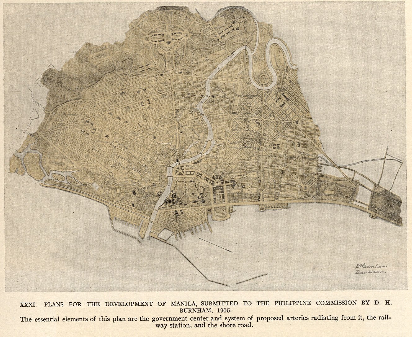
The Manila plan was the first comprehensive plan ever made for an Asian city by a Western architect. It is also one of the only Burnham plans whose paper survives intact while almost everything that was built from it has been destroyed.
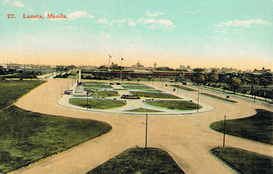
A civic center anchored on Wallace Field, the open ground south of Intramuros that the Spaniards had used as a parade ground. Burnham renamed it the Luneta and made it the symbolic and physical hinge of the city. A capitol building on its eastern edge, a legislative building to the north, a city hall, a national library, a national museum, a hall of justice. Five neoclassical structures arranged around a central plaza, the Philippine answer to the National Mall in Washington.
A diagonal boulevard system radiating out from the Luneta. Burnham overlaid Manila's existing colonial grid with three diagonals running northwest, northeast, and southeast, cutting efficient paths to the major districts and giving the city a set of monumental approaches. The diagonals would be lined with public buildings on the model of Haussmann's Paris.
A waterfront parkway. The plan called for a continuous boulevard along Manila Bay running south from the Luneta past Pasay and Parañaque, with the bay itself developed as a sequence of public parks, beaches, and yacht basins. The model was the Chicago lakefront Burnham was simultaneously planning.
A treatment of the Pasig River. The river, which cuts the city in half, would be embanked with stone walls, lined with promenades, and crossed by new bridges sized for ceremonial as well as practical use. Burnham proposed a riverfront civic district to mirror the Luneta to the south.
A summer capital at Baguio. The companion plan, delivered the same week, laid out a hill town for 25,000 people on the Cordillera Plateau, with a government complex, a market, a parade ground, residential districts on the ridges, and a perimeter park system. Baguio was meant to function as Washington functions in August: the place the government goes when the capital becomes uninhabitable.
1904 Taft commissions Burnham
6 weeks Burnham's total time on the ground in the Philippines
June 1905 Plans for Manila and Baguio delivered
1905-1914 William Parsons executes as Consulting Architect
1945 Battle of Manila destroys nearly all the executed buildings
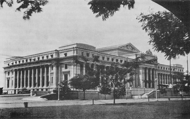
Most of the civic center, in stages, between 1908 and 1940. The Legislative Building, completed in 1926, faced the Luneta from the north and housed the Philippine Senate and House. The Manila Post Office, completed in 1926 on the bank of the Pasig, was a colonnaded neoclassical hall that anchored the river district Burnham had drawn. The Philippine General Hospital, the Manila Hotel, the Army-Navy Club, the original buildings of the University of the Philippines on Padre Faura, the Department of Finance, the Department of Tourism, the Department of Agriculture: all built per Parsons's adaptations of Burnham's program.
The Luneta itself. Wallace Field was cleared, formalized into a rectangular park with a central axis, planted, and surrounded by the public buildings the plan specified. The Rizal Monument, dedicated in 1913 to the executed national hero José Rizal, became its symbolic center. The Luneta is still there, now called Rizal Park, and remains the symbolic hinge of the Republic.
The diagonal Roxas Boulevard, originally Cavite Boulevard then Dewey Boulevard, was built along Manila Bay south of the Luneta on the line Burnham specified. It is still the city's primary ceremonial seafront and the route of every state procession.
Baguio was built almost in full. Burnham Park, in the center of town, is named for him. The Mansion House, the summer residence of the Philippine President, was built per the plan. Session Road, the main commercial street, follows the alignment Burnham drew. The city remains the summer seat of government, exactly as planned.
In February and March of 1945 the United States Army fought the Imperial Japanese Army street by street through Manila for 29 days. The Battle of Manila killed an estimated 100,000 civilians and reduced the city to rubble. By area destroyed, Manila was the second most devastated capital of the Second World War, behind only Warsaw. The Japanese commander burned what they could not hold. The American artillery flattened what the Japanese held.
The Legislative Building was gutted. The Post Office was gutted. The Manila Hotel was gutted. Intramuros, the 16th-century walled city, was 95 percent destroyed. The Department of Finance, Department of Agriculture, the original University of the Philippines campus, the Army-Navy Club: all gutted or destroyed. Burnham's civic center, which had taken 35 years to build, was substantially gone in five weeks.
What survived was the street pattern. The Luneta survived. Roxas Boulevard survived. The diagonals through Ermita and Malate survived. The Pasig embankments survived. The bones of the plan, the geometry of public space, were durable in a way the buildings were not.
The buildings that did get rebuilt, were rebuilt as restorations: the Legislative Building (now the National Museum of Fine Arts), the Post Office, the Manila Hotel. They are the architectural high points of contemporary Manila. The buildings that did not get rebuilt left holes that were filled in the 1950s and 1960s with utilitarian commercial structures that bear no relationship to the plan. Manila's modern skyline is what happens when a Burnham plan is half-rebuilt and half-replaced by parking lots.
The civic vision, the idea that public buildings should compose a coherent ensemble around a public square, was abandoned. The post-war Philippine Republic moved most government functions out of the Luneta cluster and into a new administrative district in Quezon City, planned in the late 1940s on a different model. The Burnham plan as a coordinating framework was effectively retired by the time the Republic was a decade old.
The Plan of Manila is the test case for what happens when a Burnham plan loses its political coalition. Chicago kept its plan because the Commercial Club, the Board of Education, and several generations of mayors maintained continuous institutional support for it across more than 50 years. Manila lost its plan because the Americans left in 1946, the war destroyed the executed work, and the new Republic had no institutional memory of the plan as a binding civic agreement. There was no Wacker's Manual for Manila. There was no equivalent of the Commercial Club. The plan existed on paper, was executed in stone, and then was bombed and forgotten.
It is also a reminder that Burnham's civic vocabulary was not parochial. He was working on Chicago, San Francisco, Washington, Manila, and Baguio simultaneously between 1902 and 1909. He treated the City Beautiful as a portable program, applicable to a Midwestern industrial city, a Pacific Coast earthquake town, the federal capital, a tropical colonial port, and a hill station, all at the same time. The Plan of Manila is the proof that the program scaled.
We are publishing the plan because almost no one in Manila or the United States now remembers it. The drawings are in the Library of Congress and in the Filipinas Heritage Library in Makati. The buildings that survived are some of the best in the city. The Luneta is one of the great public squares of the Pacific. None of this is taught.
The Plan of Manila is also a cautionary file in our Burnham library. It shows what a civic plan looks like without an institutional sponsor. Chicago had the Commercial Club. Manila had a colonial administration that left. Cities that want to build at this scale need a permanent civic body that outlasts any single mayor or governor. That is the lesson Manila teaches and that is the lesson we are bringing to Seattle.
Have research, archives, photos, or Manila / Baguio civic connections? Tell us who you are.